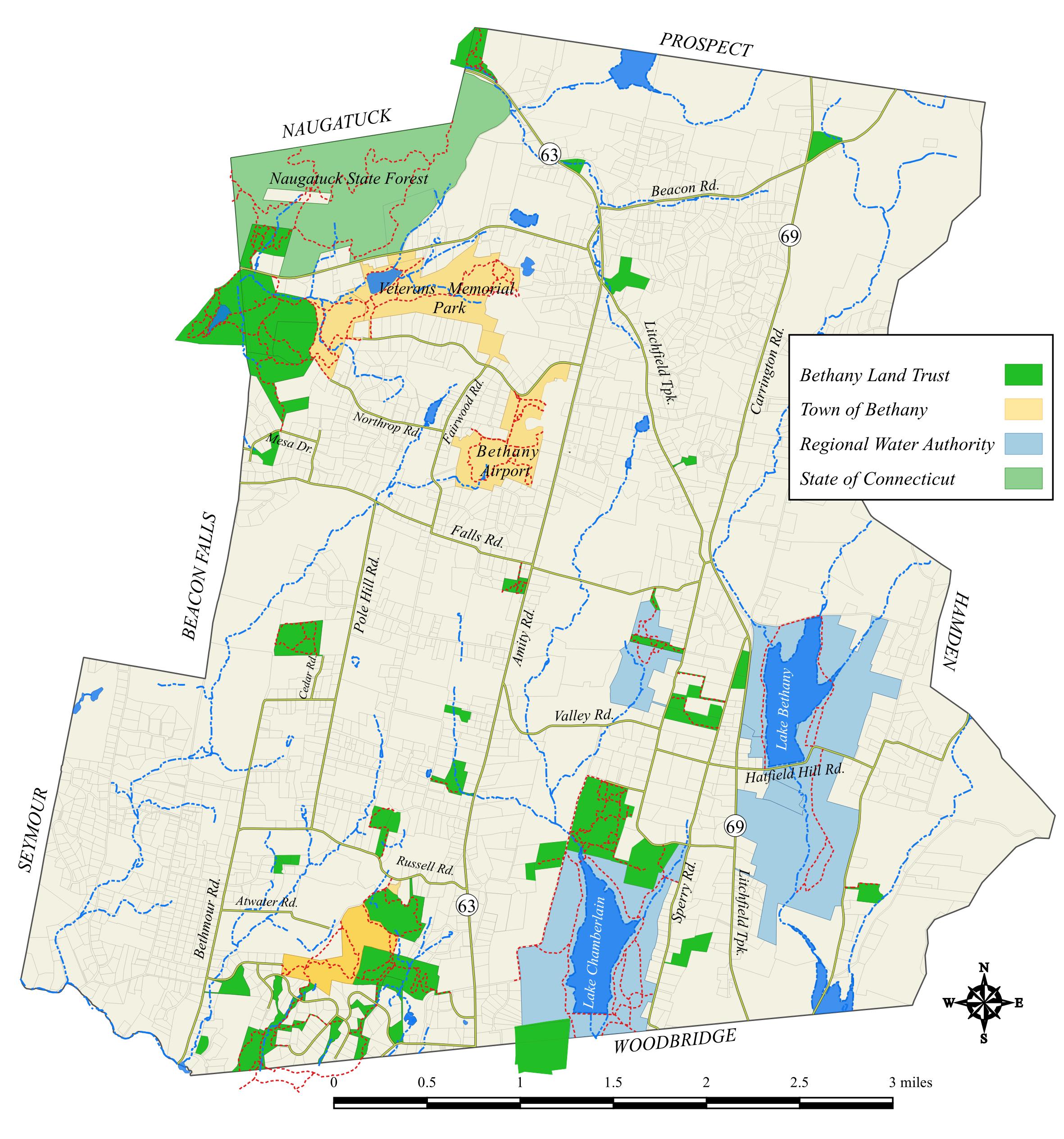
Ida Carrington-Lowell Preserve
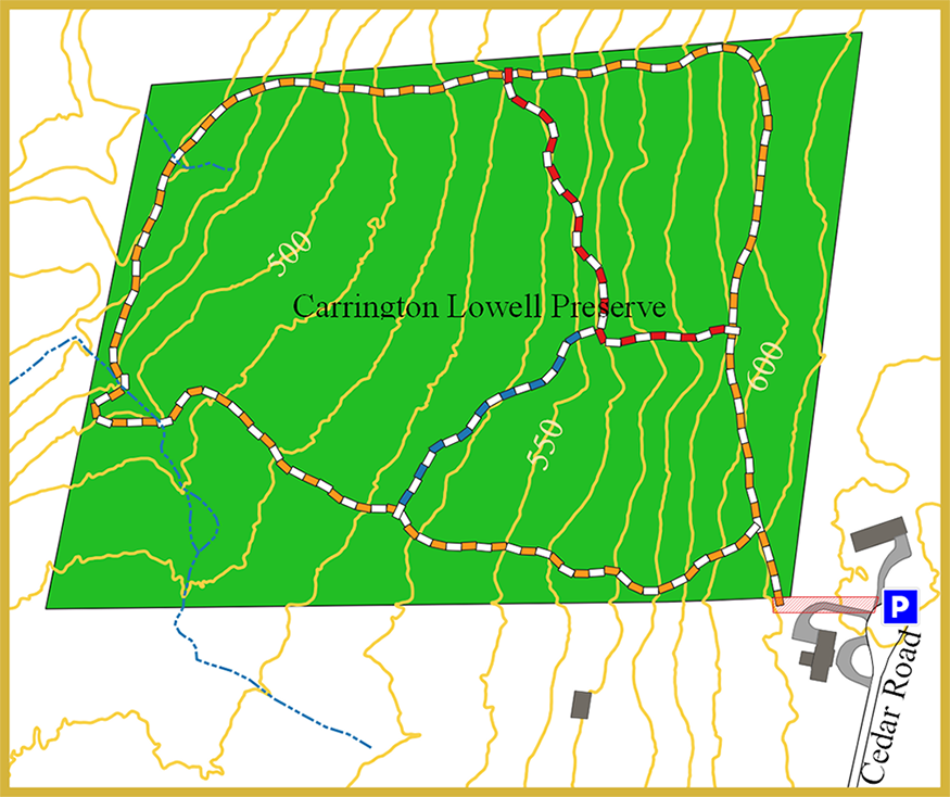
Ida Carrington-Lowell Preserve: 27 acres Trails: total 1 mile
Address: 55 Cedar Road, Bethany CT
Parking: Roadside parking at the end of Cedar Road; access to the Preserve entrance is tricky requiring hikers to walk next to a stone wall on a right–of-way on our neighbors at 45 Cedar Road. Please respect private property and keep your dog on a leash at all times.
Trail map
GPS trail map
Additional preserve information
Brief description: The first piece of property given to the Bethany Land Trust and has a perimeter trail and connecting trails that course through its center.
Delano Sanctuary/Rodell’s Roost
Delano Sanctuary/Rodell’s Roost: 6.15 acres Trails: total 0.6 miles
Address: 535 Amity Road and 15 Falls Road, Bethany CT
Parking: Parking for these two trails is located behind either Clark Memorial Library or, except for Sunday mornings, behind the Bethany Congregational Church. Parking for one car also available on Falls Road.
Trail map
Additional preserve information
Brief description: Located in the historic center of Bethany, the Edna L. Delano Nature Sanctuary and Rodell’s Roost for Robins offer hikers a short but interesting walk in the woods right next to Amity Road (Route 63).
Three Sisters Preserve
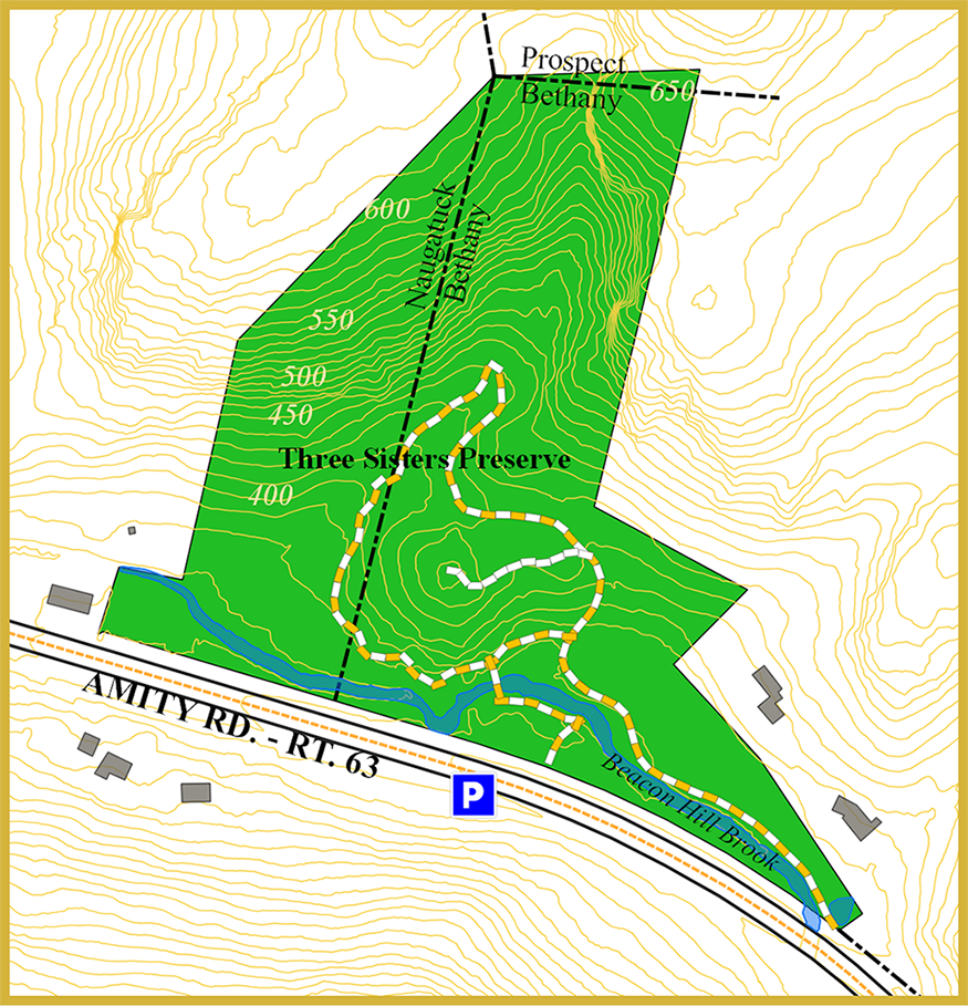
Three Sisters Preserve: 20 acres Trails: 0.5 miles
Address: 1154 Amity Road (Route 63), Bethany CT
Parking: Roadside parking exists along the western side of Amity Road with entrance to the trail across the road over the guardrail.
Trail map
GPS trail map
Additional preserve information
Brief description: The Beacon Hill Brook, a Class III Trout stream, runs through the lowlands portion of the property near Amity Road while the uplands portion rises almost 300 feet higher, featuring steep escarpments on both sides of a spectacular ravine. Remains of a dam and mill foundations can be seen from the trail.
Van Epps Preserve
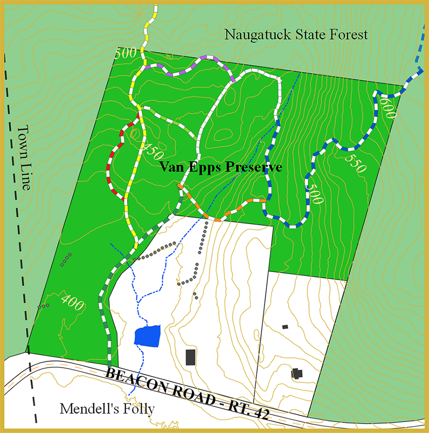
Van Epps Preserve: 22.6 acres Trails: total 1.3 miles
Address: 390 Beacon Road, Bethany CT
Parking: Roadside along Beacon Road; pull in lot behind unlocked metal gate
Trail map
GPS trail map
Additional preserve information
Brief description: The Van Epps Preserve was originally acquired in 2019 from Cathy and Dan Van Epps and expanded in 2023. Cathy and Dan created an enduring legacy in partnership with the Bethany Land Trust to preserve in perpetuity pristine forest adjacent to their home with Cathy’s Emerald Trail now named in her memory. Trails pass by house-sized glacial erratic and across crystal clear stream. Trails also climb close to 200 feet connecting with a ridge-top Blue Trail in the Naugatuck State Forest.
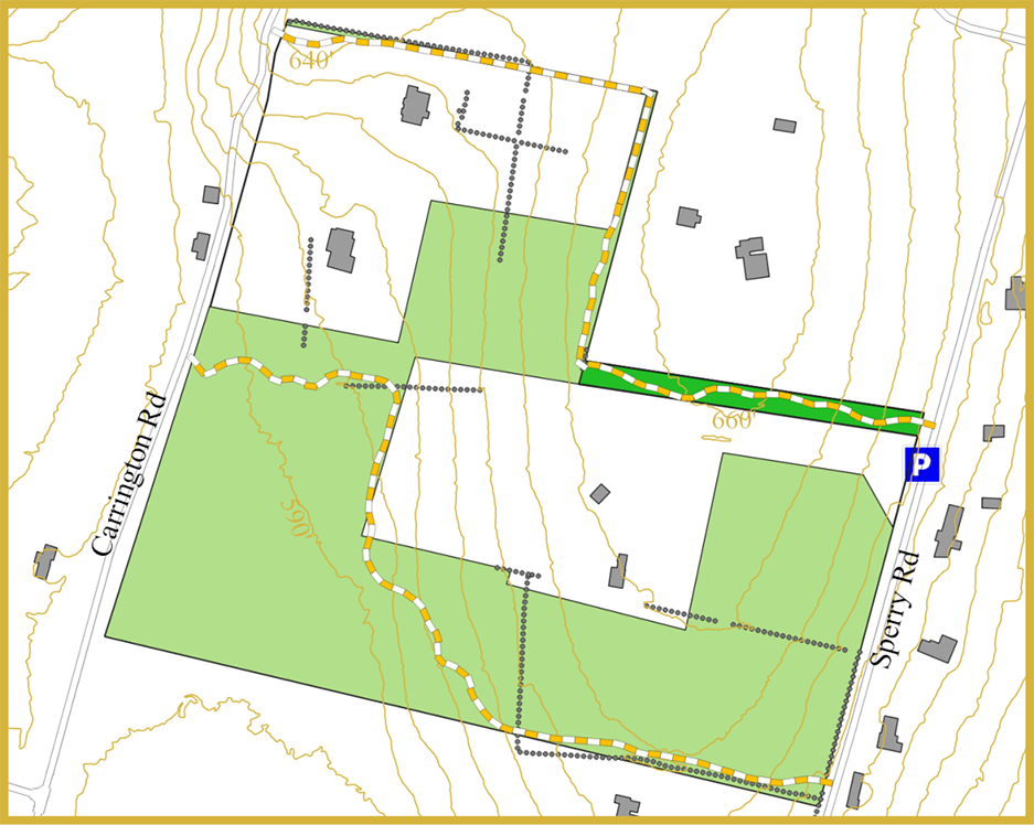
Niederman Sizer Field
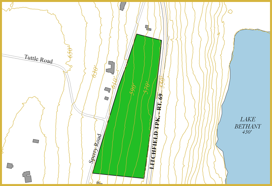
Niederman Sizer Field: 3.25 acres
Address: 406 Sperry Road, Bethany CT
Parking: Roadside parking is available
Property map
GPS map
Additional information
Brief description: The Niederman-Sizer Field is a scenic preserve and farmland, gifted to the Land Trust by James and Miriam Niederman in 2005. The field is also the site of a memorial to the late Stephen (“Steve”) Collins, Ph.D., a fervent lover of nature and, in 1968, one of the founders of the Bethany Land Trust. The Niederman-Sizer field was chosen as a site for a memorial because it provides a striking panoramic view of the ridges of West Rock State Park, an area that Steve fought to protect.
Whispering Pines
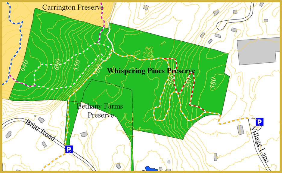
Whispering Pines: 47.4 acres Trails: total 1.75 miles
Address: Village Lane; 30 Briar Road, Bethany CT
Parking: Roadside parking is available at the end of the Village Lane cul-de-sac as well as on Briar Road.
Trail map
GPS trail map
Additional preserve information
Brief description: The Land Trust received a donation of 47.4 acres of woodlands, streams and historic features that has become Whispering Pines from the late Irene Stahl. Some of the natural features in Whispering Pines include wetlands, streams and forested ridges. Trails in Whispering Pines course through many of the natural features in the Preserve and connect with adjacent open space parcels.
Split Rock – Podoloff Trail Easements
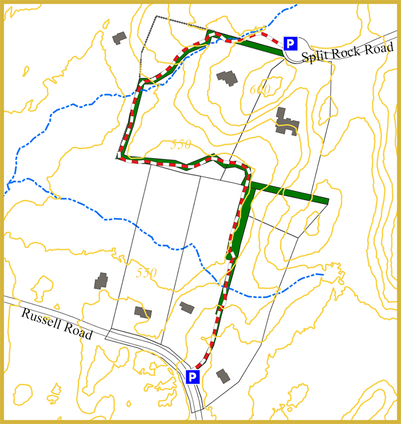
Trail: easy; 2500 feet
Address: near 134 Russell Road and 21 Split Rock Road in Bethany
Parking: Roadside parking is available on both Russell and Split Rock Roads
Trail map
GPS trail map
Additional preserve information
Brief description: The Split Rock – Podoloff trail easements were acquired by the Land Trust in 1997 and 2002 respectively as the result of open space set asides from subdivision developments.
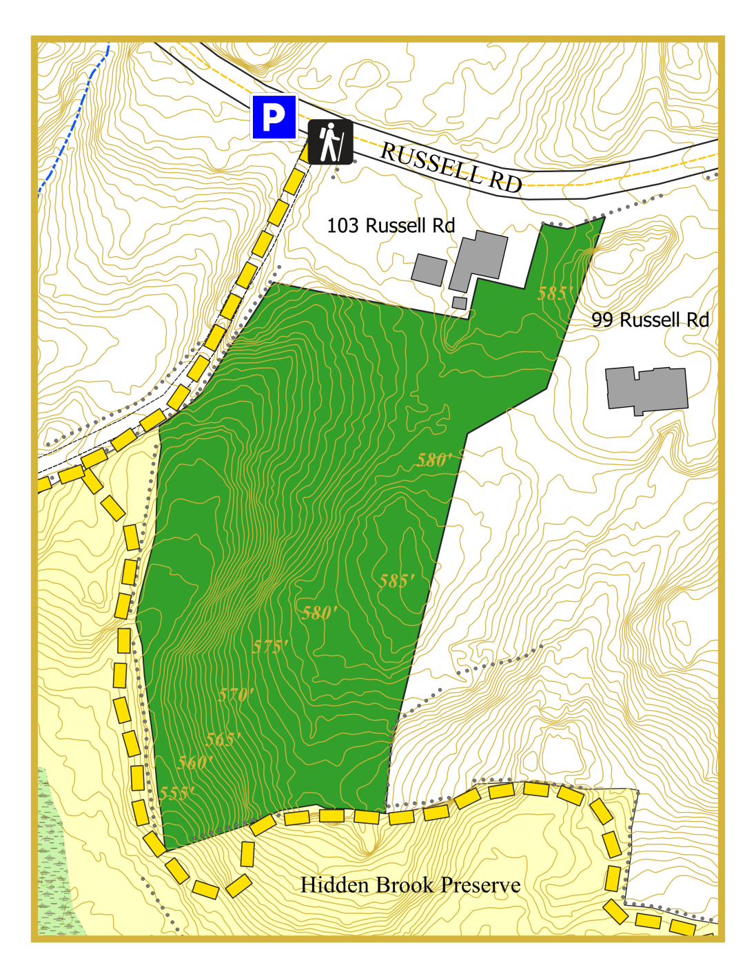
Hidden Brook Preserve
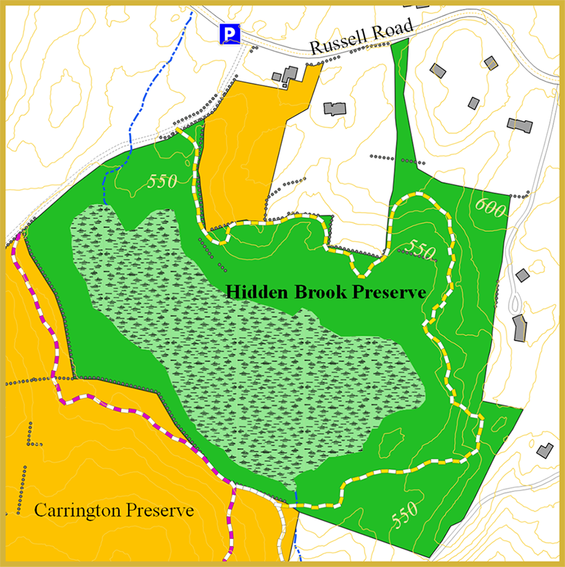
Hidden Brook Preserve: 36.1 acres Trails: total 0.7 miles
Address: 89 Russell Road, Bethany CT
Parking: Roadside parking is available where the unimproved portion of Atwater Road meets Russell Road adjacent to 103 Russell Road.
Trail map
GPS trail map
Additional preserve information
Brief description: The Hidden Brook Preserve is 36.1 acres of open space that includes approximately 8 acres of mix of woodland and rocky outcrops encircling approximately 28 acres of rich marshy swamp wetland. A trail courses through the woodlands that surround the wetland and connects with the Town of Bethany’s Carrington Preserve.
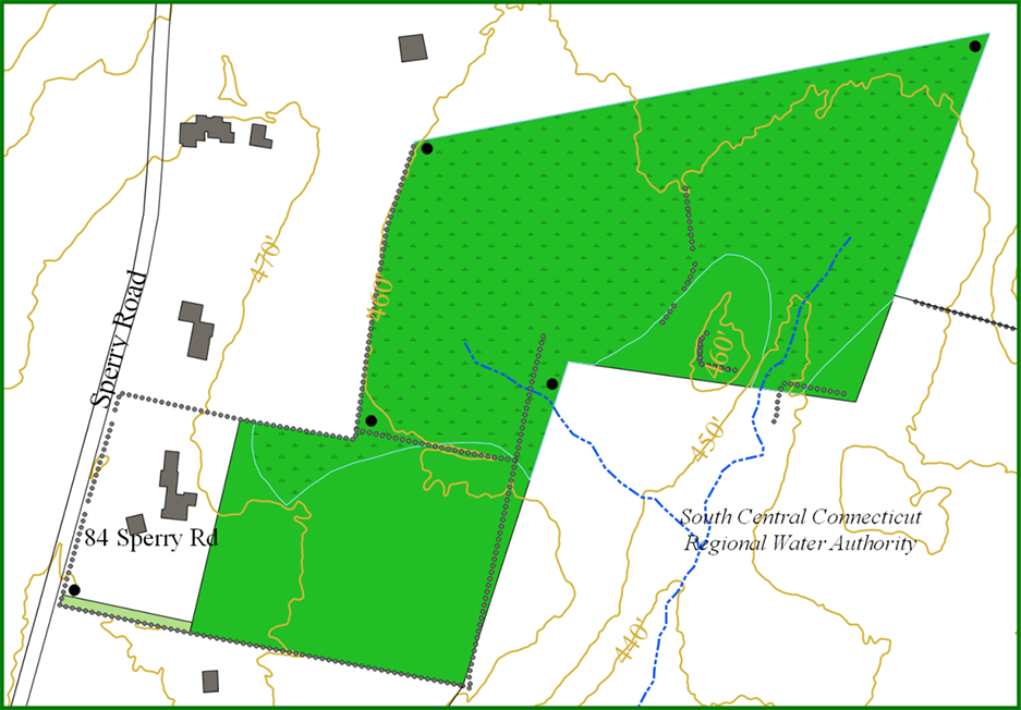
Hein Trails
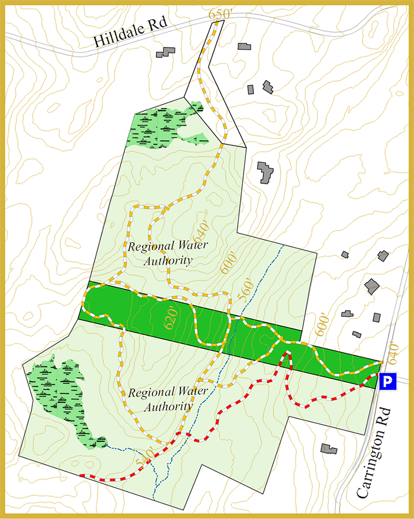
Hein Trails: 6.68 acres Trails: total 1.7 miles
Address: 191 Carrington Road, Bethany CT
Parking: The Hein Trails can be accessed most easily from 191 Carrington Road via the Litchfield Turnpike (Route 69). The trailheads start near the intersection with Tuttle Road, where parking is available on the side of the road. The Hilldale Road entrance has room for two cars.
Trail map
GPS trail map
Additional preserve information
Brief description: This property, surrounded on three sides by water company land with trails that pass through both, contains a combination of wetlands, mixed hardwood forests and rocky outcroppings with boulders the size of a small truck. Some of those outcroppings include Ambush Rock, the Rock Garden, and Council Rock.
Spykman Preserve
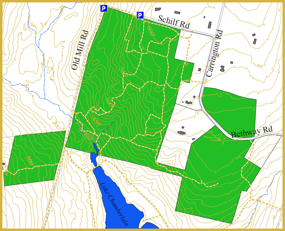
Spykman Preserve Easement: 110 acres Trails: 3.6 miles
Address: 7 Carrington Road, Bethany, CT
Parking: At the end of Schilf or Old Mill roads
Brief Description: Comprised of 3 parcels, the Spykman Preserve Easement was donated to the Land Trust in 1995 by Patricia Winer and Angelica Harter. The property is covered by mixed hardwood forest, some pine forests and some open fields. The property is in the West River watershed and slopes down toward the Sargent River, which crosses the southwest corner of the property. Trails on the property are used for both hikers and horseback riders and are contiguous with recreational trails in the adjacent Lake Chamberlain tract owned by the Regional Water Authority.
Welch Parcels
Welch Parcels: 24 acres with easements Trails: total 1.5 miles
Address: 385 Sperry Road, Bethany CT
Parking: The Welch Parcels can be accessed most easily off Sperry Road via the Litchfield Turnpike (Route 69). Roadside parking is available at the trailheads.
Trail map
GPS trail map
Additional preserve information
Brief description: The Welch Parcels, which include four easements protected by the Bethany Land Trust and a 50-foot-wide strip owned by the Trust, preserve more than 24 acres between Sperry and Carrington Roads. Walking the trails and along Sperry and Carrington Roads provides a short, pleasant loop hike.
Grobe Preserve
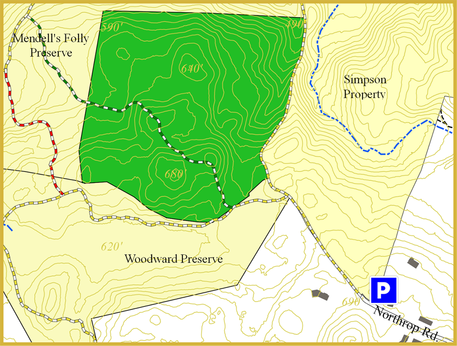
Grobe Preserve: 25.2 acres Trails: total 0.9 miles
Address: 337 Beacon Road (Route 42), Bethany CT
Parking: Being surrounded by other open space, the Grobe Preserve is accessed via trails connecting from other parcels including Mendell’s Folly and the Woodward Nature Preserve. The closest access point is through an entrance to the Woodward Nature Preserve at the end of the paved portion of Northrup Road, where roadside parking is available. It is about 0.2 miles from this parking area to the Green Grobe Gadabout Trail.
Trail map
GPS trail map
Additional preserve information
Brief description: The Grobe Preserve, part of the Bethany’s northwest corner greenway, is a topographically complex parcel with steep to moderate slopes, valley features, and at least three summits ranging to about 700’ above sea level. A trail connects Grobe with Mendell’s Folly and the Woodward Nature Preserve.
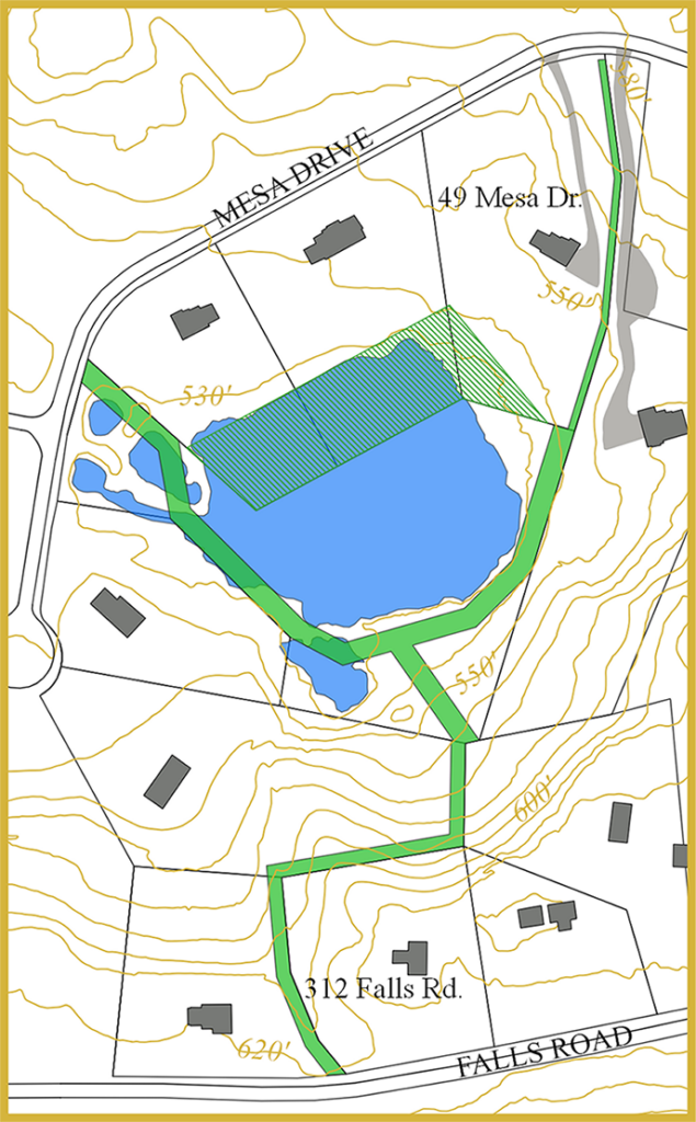
Woodward Nature Preserve
Woodward Nature Preserve: 36.4 acres Trails: total 1.2 miles
Address: Mesa Drive, Bethany CT (adjacent to 46 Mesa Drive)
Parking: Road side parking is available on Mesa Dive; trail entrance is adjacent to 46 Mesa Drive. Another entrance is at the end of the paved portion of Northrup Road, with access through a gate onto the abandoned portion of the road.
Trail map
GPS trail map
Additional preserve information
Brief description: The 36.4-acre Woodward Nature Preserve, an important part of the Bethany’s northwest corner greenway, was obtained by the Land Trust as a subdivision set aside. Natural features include rocky ridges, vernal pools, and an extensive wetlands with an outlet stream that empties into the beaver pond in Mendell’s Folly. Trails in Woodward connect with those in Mendell’s Folly and the Grobe Preserve.
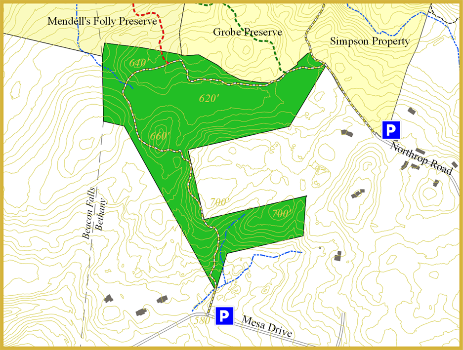
Mendell’s Folly
Mendell’s Folly : 125 acres Trails: total 2.8 miles
Address: 337 Beacon Road (Route 42), Bethany CT
Parking: Roadside parking is available along Beacon Road (Route 42) at the Van Epps Preserve. Trail entrance is across Beacon Road by the wetlands. Another entrance is located off Route 42 in Beacon Falls, with limited parking (1 or 2 cars) by the side of the road.
Trail map
GPS trail map
Additional preserve information
Brief description: As the centerpiece in Bethany’s northwest corner greenway, Mendell’s Folly provides hiking opportunities with trails that connect with three other preserves and is part of an area identified as a Nature’s Network Connector that resides between terrestrial and wetland core areas. Mendell’s Folly provides moderate to difficult trails that course through wetlands with a beaver dam, climb up ridges and pass through our natural features on the property.
Bethany Farms
Bethany Farms: 70 acres Trails: total 3.5 miles
Address: 59 Farm View Road, Bethany CT (other entrances exist on Country Lane, Sanford Road, and Chelsea Circle)
Parking: Roadside parking is available at the many trail entrances within the system as well as along Sanford Road in Woodbridge.
Trail map
GPS trail map
Additional preserve information
Brief description: Located in the southwestern corner of Bethany, the Bethany Farms parcels, encompassing 70 acres and trail easements, was created by the Bethany Land Trust to provide a peaceful retreat within one of Bethany’s largest housing developments. The Bethany Farms Trail System consists of several trails, including some that connect with remnants of the old Naugatuck Trail in Woodbridge to offer a variety of hiking experiences.
Bethany Airport
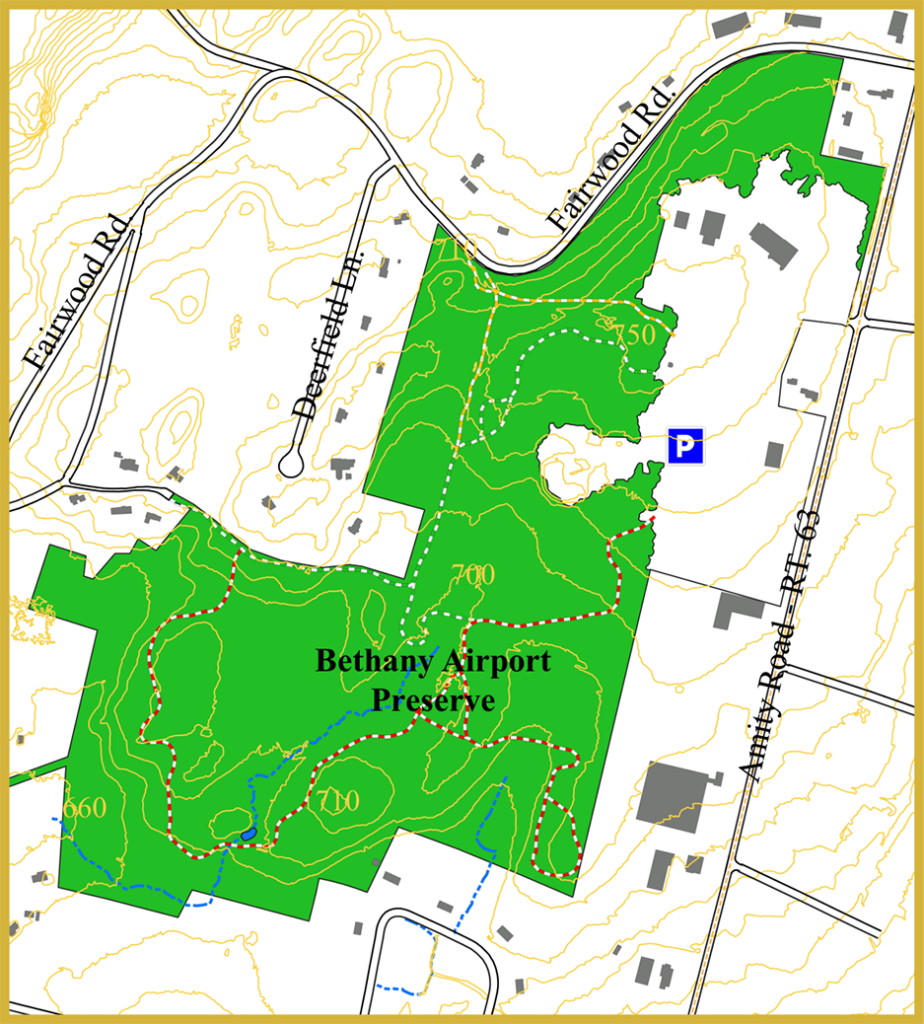
Bethany Airport : 112 acres Trails: total 1.89 miles
Address: 775 Amity Rd.
Parking: Parking is ample on the Airport property along the main drives through the open area. Access is from two main entrances on Amity Road.
Trail map
GPS trail map
Additional property information
Brief description: Bethany Field, later known as Bethany Airport, was opened in 1923. It was one of the first airports in New England and closed in 1965. Purchased by the town in 1967, it is a multipurpose property with a recycling center, two equestrian rings, announcer’s stand and a soccer field. It was expanded to include the town’s main fire station. The trails are in the wooded western area of Bethany Airport property and are generally level, with some seasonal wet areas.
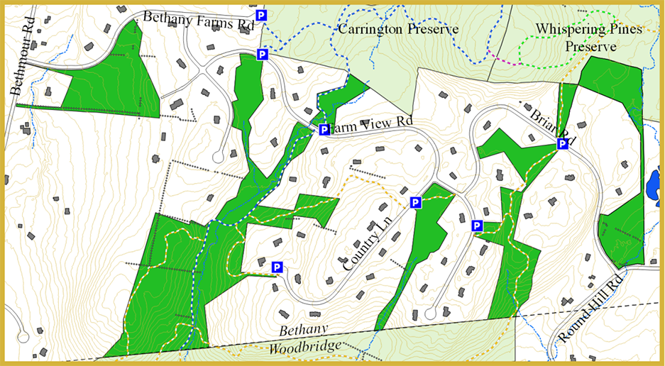
Carrington Preserve
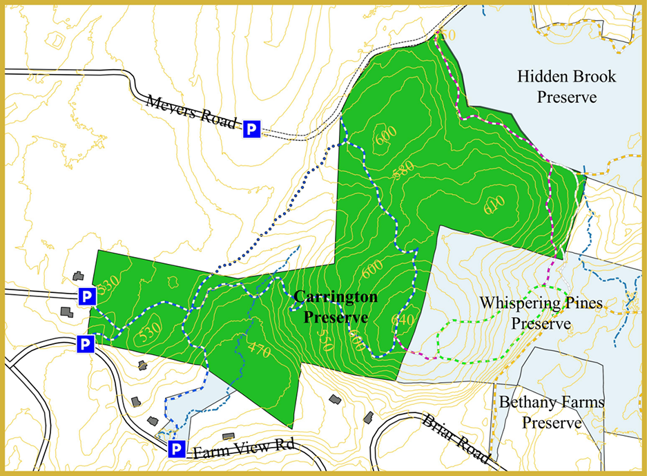
Carrington Preserve: 73.75 acres Trails: total 2 miles
Address: 120 Atwater Road, Bethany CT
Parking: Roadside parking is available in the town’s parking lot at the end of the paved section Atwater Road. Please don’t block access to the Cherry Tree Farm’s fields. Roadside parking is also available on the Bethany Farms Road cul-de-sac and along Farm View Road.
Trail map
GPS trail map
Additional preserve information
Brief description: The Carrington Preserve was purchased by the Town of Bethany in 2015 and is managed by the Bethany Land Trust. Trails in the Carrington Preserve maintained by the Land Trust connect with those in Whispering Pines, Bethany Farms and Hidden Brook. Part of the historic Naugatuck Trail courses through the property.
Simpson Preserve
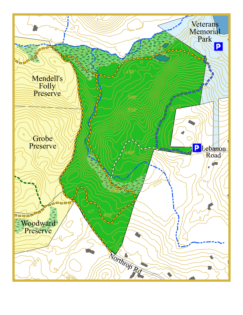
Simpson Preserve: 50.88 acres Trails: total 2.1 miles
Address: 327 Beacon Road, Bethany CT
Parking: In Veterans Memorial Park and at the end of Lebanon Road.
Trail map
GPS trail map
Additional preserve information
Brief description: The Town of Bethany purchased 50.88 acres of undeveloped land from the Simpson family in 2025. The Bethany Land Trust provides trail and habitat management services for the parcel. The Simpson Preserve is a largely unfragmented tract of mature and maturing upland forest interspersed with midslope and riparian communities. Trails in the Preserve connect hiking trails in Veterans Park to multiple Land Trust preserves.
Veterans Memorial Park
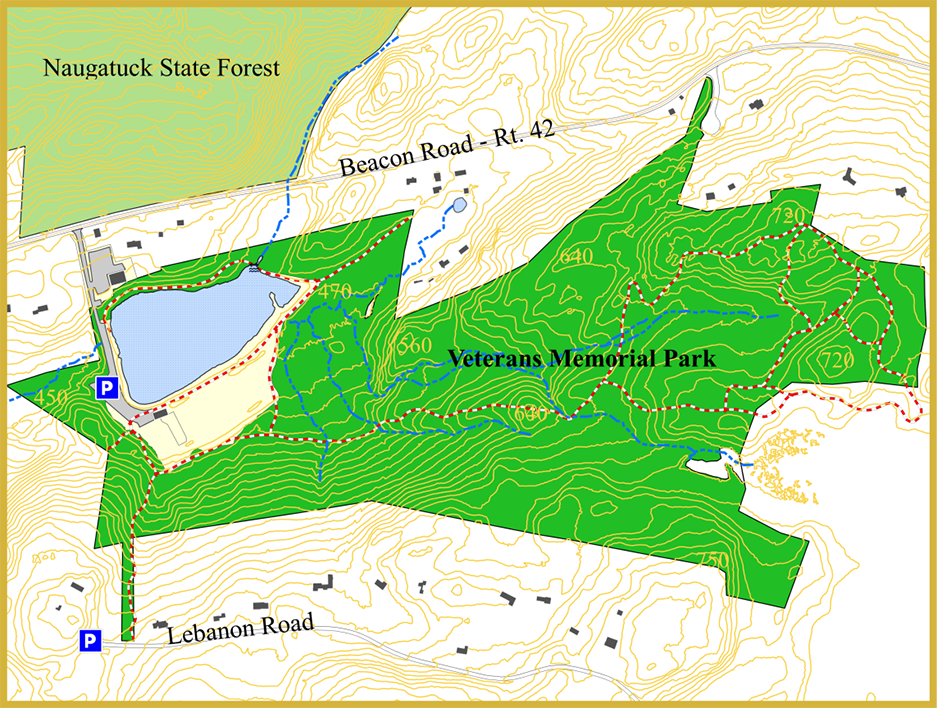
Veterans Memorial Park: 149 acres Trails: approx. 2 miles
Address: 265 Beacon Road
Parking: Parking is available in the parking lot; non-resident permit required.
Trail map
GPS trail map
Additional property information
Brief description: Owned by the Town of Bethany, Veterans Memorial Park provides residents with hiking trails, a lodge, an open-air pavilion, basketball and tennis courts, a playground, an open area for athletic activities, and a man-made lake for swimming.
For more information: https://bethany-ct.com/maps/parks
Amber Fields
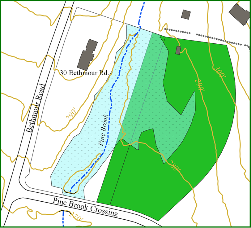
Amber Fields Easement: 3.27 acres Trails: none
Address: 25 Pine Brook Crossing, Bethany CT
Brief description: This easement along Pine Brook was created with the Kleeman family in 1990 to protect its natural beauty and restrict future development.
Clements
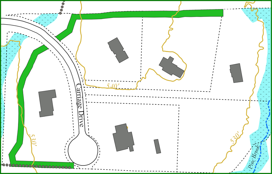
Clements Easement: 0.46 acres Trails: none
Address: Carriage Drive, Bethany CT
Brief description: This easement was created with the Clements family in 1992 as a subdivision set aside.
Cooper
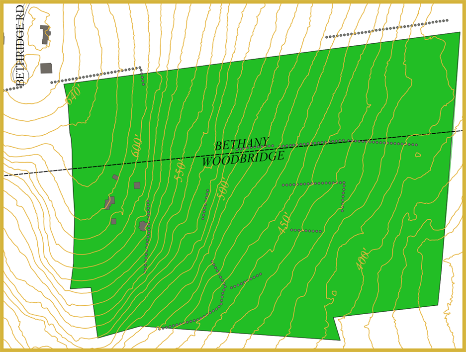
Cooper Agricultural Easement: 51 acres Trails: none
Address: 55 Bethridge Road, Woodbridge, CT
Brief description: In 2011, Peter Cooper and Diana Cooper donated a 29-acre agricultural easement on land in Woodbridge and in 2012, added 18 acres on land in Bethany. Four more acres were added in 2024. The Cooper easement expands a fabulous greenway protecting habitat that starts with the Spykman Preserve through the RWA managed forest to these 51 acres.
Hershman’s Hollow
Hershman’s Hollow: 2.24 acres Trails: 0.3 miles
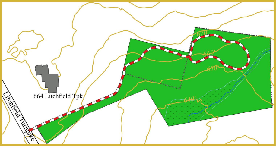
Address: 658 Litchfield Turnpike, Bethany, CT
Parking: Roadside parking is available.
Trail map
GPS trail map
Additional preserve information
Brief description: This smaller parcel containing woodland and wetland habitat was donated by Dorothy Hershman in 1998. Rock walls are a prominent feature of the parcel forming the northern and eastern borders while another section is found in the interior. A small stream feeds the wetlands.
Hall Preserve
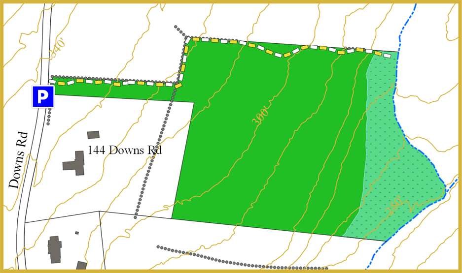
Hall Preserve: 8.08 acres Trails: total 0.3 miles
Address: 152 Downs Road, Bethany CT
Parking: Limited roadside parking is available
Trail map
GPS trail map
Additional preserve information
Brief description: Given to the Land Trust in 1995 by Dr. John W and Betty Hall, the Hall Preserve is a wooded parcel bordering water company land. A trail leaves the roadside and follows alongside walls eventually ending at the side of a stream that flows into Lake Watrous.
Kleeman Egger/Stronk
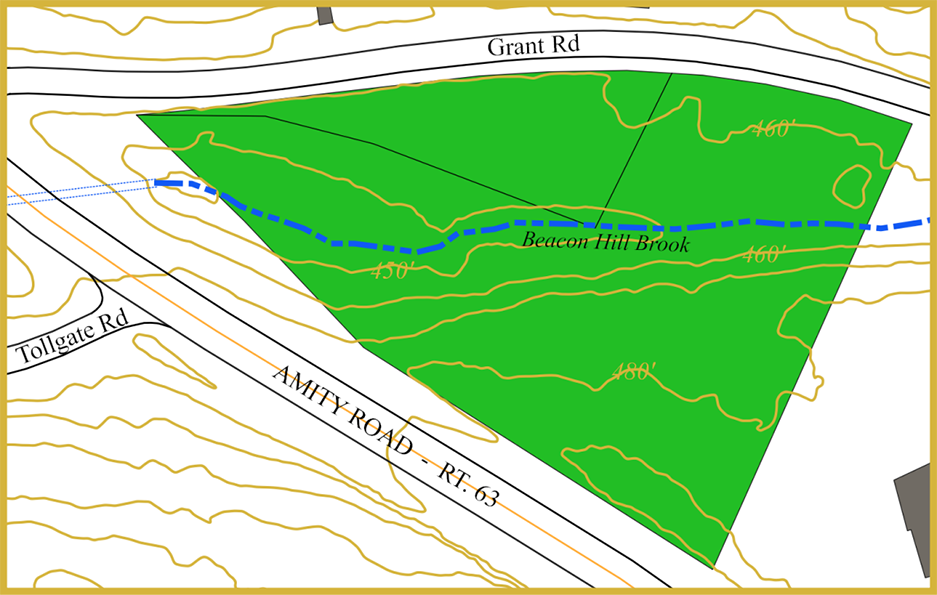
Kleeman Egger/Stronk Parcels: 2.93 acres Trails: none
Address: 1030 Amity Road and 81 Grant Road, Bethany, CT
Brief description: These adjacent wooded parcels are found in the northern section of Bethany along Beacon Hill Brook where Grant and Amity Roads meet. The 0.5-acre Raymond Stronk Memorial Site was granted to the Land Trust by John F. Pease in 1994 while the 2.43-acre Kleeman Egger parcel was donated in 1996 by James Kleeman and David Egger. The Kleeman Egger parcel contains the remains of a mill pond and dam that were associated with the Perkins Sawmill once located on the west side of Amity Road.
Liuzzi Easement
Liuzzi Easement: 0.58 acres Trails: none
Address: 892 Amity Road, Bethany, CT
Brief description: This 20-foot-wide easement was created as a subdivision set aside in 2007 and runs along the southeastern and eastern borders of the larger property.
Luke Hill Preserve
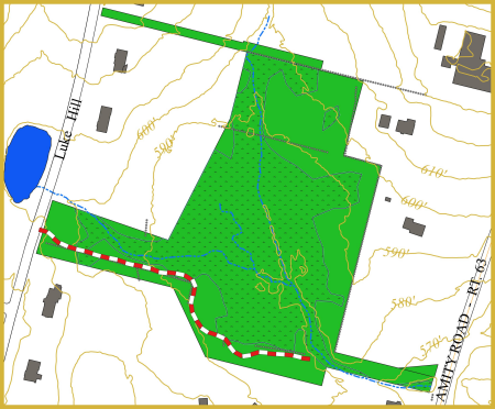
Luke Hill Preserve: 11.99 acres Trails: total 0.3 miles
Address: Luke Hill Road, Bethany CT
Parking: Roadside parking is available
Trail map
GPS trail map
Additional preserve information
Brief description: Obtained by the Bethany Land Trust in 2004 as a subdivision set aside, the Luke Hill Preserve includes a large wetland from which emerges a stream that flows into the Sargent River.
Old Dayton Road
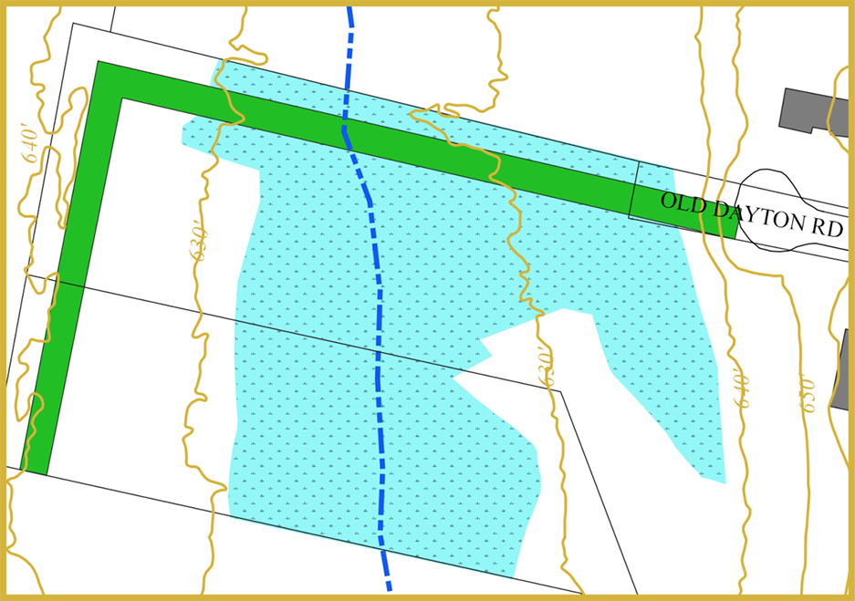
Old Dayton Road Easement: 0.5 acres Trails: none
Address: End of Dayton Road, Bethany, CT
Brief description: This easement strip was created in 1993 as a subdivision set aside and runs from the end of Dayton Road along portions of land designated as an “old road” ending on Luke Hill Road near Amity Middle School.
Podgwaite Preserve
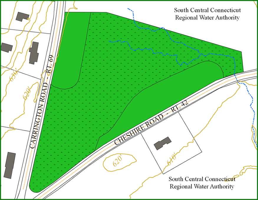
Podgwaite Preserve: 8 acres Trails: none
Address: 780 Carrington Road, Bethany, CT
Brief description: Donated by the Podgwaite family in 1998, the Podgwaite Preserve is located northeast of the intersection of Routes 42 and 69. The preserve contains a large wetland that drains across Route 42 into a larger wetland system forming Sanford Brook.
Shaw Preserve
Shaw Preserve: 10 acres Trails: none
Address: 74 Sperry Road, Bethany, CT
Brief description: Donated as a testamentary gift by Marjorie Shaw in 1995, the Shaw Preserve contains both wetlands and forested areas with a small stream flowing south toward Woodbridge.
Watch Hill
Watch Hill Easement: approx. 0.5 acres Trails: none
Address: Falls Road to Mesa Drive, Bethany, CT
Brief description: Created as a subdivision set aside in 2003, the easement courses from Falls Road down to and skirts around a wetland and ends on Mesa Drive.
Lake Bethany
Lake Bethany: 513 acres Trails: total 4 miles
Address: Hatfield Hill Road, Bethany CT
Parking: The Lake Bethany gated entrance and parking area is located along Hatfield Hill Road adjacent to the overhead power line.
Trail map and additional property information
Brief description: Lake Bethany is a Regional Water Authority (RWA) reservoir and Recreation Area. There are four miles of scenic trails that follow the lake shore and a scenic ravine carved out by the West River. Hiking on the trails requires a permit from RWA. Additional Information about trails, parking, and permits for accessing the hiking trails can be obtained by visiting the RWA website: https://www.rwater.com/about-us/in-the-community/recreation
Lake Chamberlain
Lake Bethany: > 500 acres in Bethany and Woodbridge Trails: total approximately 7.5 miles
Address: Sperry Road, Woodbridge, CT
Parking: Lake Chamberlain’s gated entrance and parking area is off Sperry Road.
Trail map and additional preserve information
Brief description: Lake Chamberlain is a Regional Water Authority (RWA) reservoir and Recreation Area along the Sargeant River in Bethany and Woodbridge. There are approximately 7.5 miles of hiking trails and hiking on the trails requires a permit from RWA. Additional Information about trails, parking, and permits for accessing the hiking trails can be obtained by visiting the RWA website: https://www.rwater.com/about-us/in-the-community/recreation
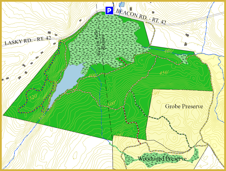
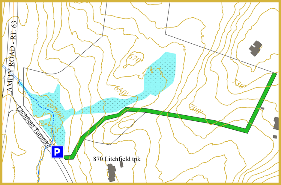
Naugatuck State Forest
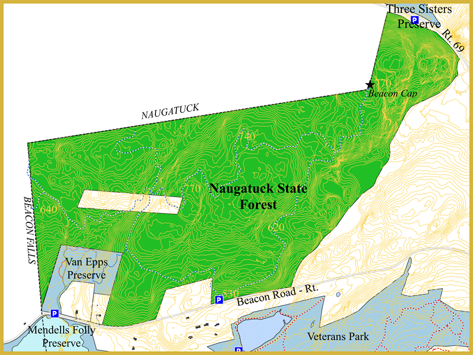
Naugatuck State Forest: > 5000 acres in Bethany, Naugatuck, Beacon Falls, and Oxford
Trails: total approximately 4 miles in Bethany
Address: 320 Beacon Road, Bethany, CT
Parking: The dirt Whittemore Trail parking area at 320 Beacon Road holds about four cars.
Trail map and additional information
Brief description: The Naugatuck State Forest has almost 5,000 acres of wild, undeveloped woodlands, grasslands, rivers, lakes, ravines, and swamp in the scenic Naugatuck River valley. Trails in the East Block of the forest that includes Bethany connect with trails in the Van Epps Preserve. For more information, visit the CTParks website: https://ctparks.com/parks/naugatuck-state-forest